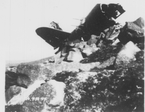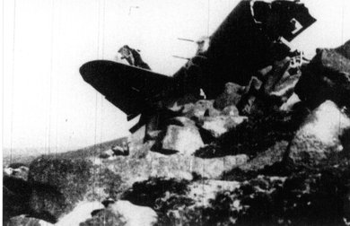
Rear section of 41-18150, Chimney Rock Mountain 16th April 1944
On the 10th April 1944 three B26 Marauders took off from Toome Airfield on a routine "Gunnery Mission" which was to take place in the Irish Sea close to Greencastle. County Down. The weather on that day was discribed as "Visibility 4 miles, Stratus clouds at 1000 feet, overcast with breaks, reported haze." At approximately 1530hrs the aircraft were circling just off the coast close to the town of Kilkeel however one of the planes, flown by 2nd Lt Howell Osborne jr, 41-18150 "Winnie Dee" had dropped out of formation and was lagging behind. Before it could rejoin the group it disappered into a cloud bank never to be seen again.
Unable to establish contact with the missing plane the other two aircraft returned to Toome airfield and reported its disappearance. It was not until the following day that it was located after members of the 5th Infantry Division, whilst on a routine hike in the Mourne Mountains, came across wreckage on Chimney Rock Mountain, there were no survivors. Offical confirmation of the crash didn't reach Toome airfield until the 15th April.
In this section of the website I'm going to take a detailed look at the circumstances of the accident. I'll present statements made by the pilots of the other planes, evidence from James Cousins who was working in the Mournes on that day, the conclusion reached by Major Commenator and an extract from local author Noel Kirkpatrick's book "Take a Second Look Around County Down". In his publication he mentions discovering the remains of the plane on the mountain in the 1950's.
I fully accept that its been over 80 years since the crash but there are a few parts of the offical findings and evidence that I'd like to question.
First of all the statements made by the two pillots:
Statement of pilot flying No. One (1) position 17th April 1944
"I was flying the lead ship of a three (3) ship formation on a Gunnery Mission near Greencastle. I was flying ship No. 025 Lt E.G. Wegman was flying the right wing in No. 054 Lt H.C. Osborne jr was flying my left wing in ship No. 150. Lt. Osborne was out of position, approximately 400 feet low and 1500 feet in back of us. We were circling to get over a cloud bank building up on the Mourne Mountains when he disappeared into it. We were approximately three (3) miles of Kilkeel at the time, at an altitude of 2500 feet. When he disappeared I called giving him my altitude and course (280 de-grees) but found radio contact had been lost. This was approximately 1530hrs. He did not come up through the overcast or acknowledge future radio calls, so we returned to base."
Richard A. Newman
2nd. lt. Air Corps.
I believe that there was a typo when Lt Newman refered to Ship No. 025. The only B26 this number could refer to was lost in a flying accident the year before. There is a strong possibility the plane was in fact 41-18022, El Diablo. This plane served with the 3rd CCRC at Toome. Below is a photo of N0. 022 the unit code on the side of the fusalage is the unit code for the 3rd CCRC.
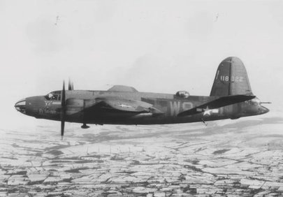
B26 41-18022 El Diablo
Statement of pilot Flying N0. Two (2) position. 17th April 1944
"On April 10 1944, at approximately 1530hrs, our three (3) ship formation led by Lt R.A Newman was circling directly east of the town of Kilkell and approximately two (2) miles out in the Irish Sea. I was ring wing man (No. 2 position) in N0. 054 and Lt H.C. Osborne was left wing man (No.3 position) in No.150. The lead ship was at an approximately 2500 or 2600 feet, flying shoreward on a course of 280 degrees. The top of the cloud overcast was about 2000 feet. At this time Lt. Osborne was flying about 400 feet below the lead ship and 1200 to 1500 feet back. While in this position he entered the cloud bank and we never saw the ship again. The lead ship made two (2) attempts to contact him by radio but was unsuccessful on both occasions. Previously to this, all ships had good interplane contact on radio.
At no time did the lead ship take his formation through the overcast, and had Lt. Osborne in No. 150 been flying a normal formation, would never have entered the solid cloud deck.
Eugene G. Wegman
2nd. lt. Air Corps
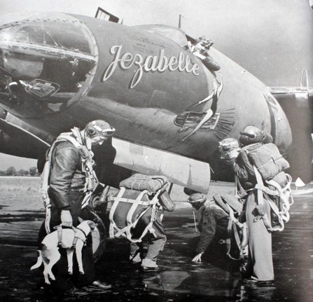
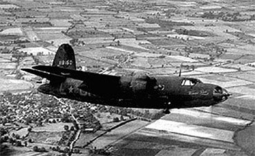
Lt Wegman's plane on the 10th April 1944, 41-18054 Jezabell
Additional information and diary entry from B26 C0-Pilot
A few years ago a friend and fellow aviation enthusiast Gary McFarland recieved an Email from the daughter of one of the co-pilots flying the same mission that day. He had originally been Howell's co-pilot but was moved to another crew at some stage before the crash. She recalled what her father had told her about the crash and also shared an extract from his diary referring to the day in question.
"He said that Osborne's aircraft dropped out of the three ship formation and they repeatedly called them on the r/t without reply, the aircraft was last seen flying into cloud formations over the Mournes and disappeared from view."
Diary entry 10th April 1944
"Lt Osborne and crew cracked into a mountain side here in North Ireland. All were killed. Dick was flying lead ship. Osborne couldn't keep up with formation. Last they saw of him, he went through a cloud bank. Apparently it had a stone centre. Back in the States I was on Osborne's crew for two months. Almost shipped out with him."
Major George C. Commenator's Conculsions
"While returning from a Gunnery Training Mission the pilot flew into cloud formations and crashed into a mountain. (Chimney Rock Mountain, Mourne Mountain Area.)
Lt Osborne, pilot of Aircraft N0.41-18150 made an error in technique by permitting himself to get too far out of position in formation.
The pilot made an error in judgement by flying into clouds in a known mountainous area.
No recommendations.
George C. Commenator
Major Air Corps
James Cousins Quarry Worker.
A number of years ago the late Ernie Cromie of the Ulster Aviation Society spoke to James Cousins of Glasdrumman. He was working in the quarries near the head of the Bloody Bridge river valley which runs up the eastern side of Chimney Rock Mountain on 10th April 1944. Ernie recalled what James told him in an article which appeared in a local publication "Twelve Miles of Mourne".
"He heard the engines of a plane approach his location from the direction of the sea. The sound got louder and louder until he thought the plane was going to crash on top of him then suddenly the engines revved up and the plane seemed to turn away to the south and the noise died away."
"He was unaware that the plane had crashed into Chimney Rock because thick mist and an intervening ridge blocked the sound of the impact."
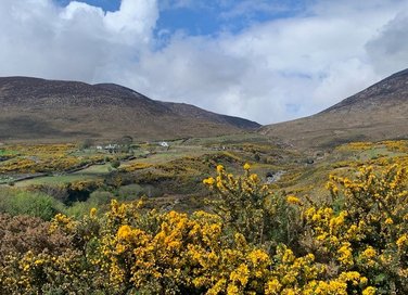
View of Bloody Bridge river valley from the coast and further on up the valley.
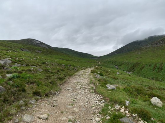
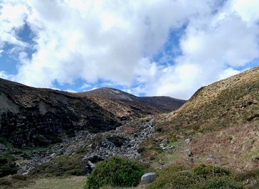
The top of Bloody Bridge river valley with the quarry at the end of the path and Chimney Rock to the left
Noel Kirkpatrick
In the 50's before the remains of the aircraft were removed from the mountain site, Noel Kirkpatrick came across the crash site, here is an extract from his book:
"I traced the flight path from the aeroplanes first contact with the mountain where it left trimming tabs and further on pieces of the tail assembly to the entire fuslage and wings etc. Finally after careful planning and searching I managed to locate the missing sections almost a quarter of a mile to the east and several hundred yards away in a gully lower down the mountain"
After reading the information above here are a number of points I'd like you to consider.
1. Both pilots state that they were two to three miles off the coast, east of Kilkeel, Wegman also added that they were flying shoreward on a course of 280 degrees with Osborne lagging behind and below the formation. This seems to be contradicted however when Newman mentions that they were circling to get over a cloud bank building up on the Mourne Mountains.
The C0-pilots diary entry also contradicts things when it states that Osborne's aircraft "was last seen flying into cloud formations over the Mournes."
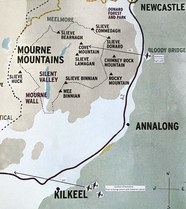
If you look at the diagram below you can see that I have plotted the alleged position of the formation when Osborne's plane disappeared. There is no mention in either pilots statements that he was flying in a different direction from the formation when he disappeared, just below and behind them. I therefore think I can safely conclude that he was also flying shorewards on a course of 280 degrees as well.
Considering this I don't believe they were two to three miles east of Kikeel, I think they were further up the coast east of the Mourne Mountains. If they where where they said they where then why were they circling to get over a cloud bank over the Mournes? Why did the co-pilot state that Osborne flew into a cloud formation over the Mournes and how did Osborne's plane end up flying in from the sea up Bloody Bridge river valley on a course of roughly 280 degrees approximately 8 miles further up from his last known position east of Kilkeel?
2. Why was Osborne's plane lagging behind? Both pilots recalled that he was 400 feet below the formation and approximately 1200-1500 feet behind, was this the result of an error on his part or was his aircraft suffering from performance issues? Bearing in mind that his aircraft was classified as "War Weary".
Wegman stated that the top of the "cloud overcast" was 2000 feet and that the main formation was at 2500 feet putting Osborne at approximately 2100 feet. Slieve Donard the highest Mountain in The Mournes is 2790 feet, Slieve Commedagh 2520 feet, Slieve Binnian 2450 feet and Chimney Rock 2152 feet. If Wegman was correct in his assessment of the top of the cloud bank then at least four mountain peaks would have been visible above the clouds. I myself have experienced this one time while walking in the Mournes. As I ascended Chimney Rock I broke through the cloud base at approximately 1700 feet and I could clearly see miles in all directions including most of the Mountain peaks. There was nothing above me but blue skies and it was as hot as a summers day even though it was November, however the land below was completely hidden underneath a carpet of cloud that resembled a winter wonderland.
If Wegman was correct about the height of the cloud base then before he entered the clouds Osborne would have had a view of the mountain tops. When this view was lost in the cloud bank why didn't he climb back up above the clouds to re-establish the view especially when he may have known that he was close to a mountain range? In a B26 this would have taken a matter of seconds, was it because as I previously mentioned he was having issues with his aircraft? Its unfourtunate but if he had maintained a ceiling of 2100 feet then a mere fifty odd feet was the difference between clearing the top of Chimney Rock and connecting with the top of it.
3. The loss of communications. Before Osborne's disappearance it was stated there was good interplane contact and that after Osborne entered the clouds it was lost. I think the answer to that is that
the crash occured shortly after Osborne disappeared form view and thats why they couldn't contact him.
Finally why did Wegman feel it neccessary to include this final line in his statement in defence of Newman?
"At no time did the lead ship take his formation through the overcast, and had Lt. Osborne in No. 150 been flying a normal formation, would never have entered the solid cloud deck."
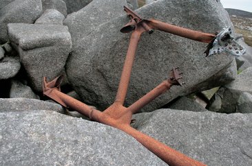
Engine mount from one of 41-18150 engines
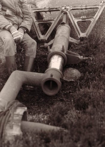
One of the main undercarriage legs that use to lie on the mountain. It was recovered by the Ulster Aviation Society circa 1980's
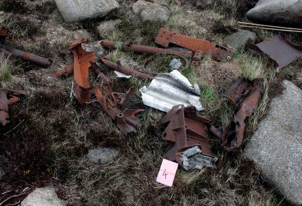
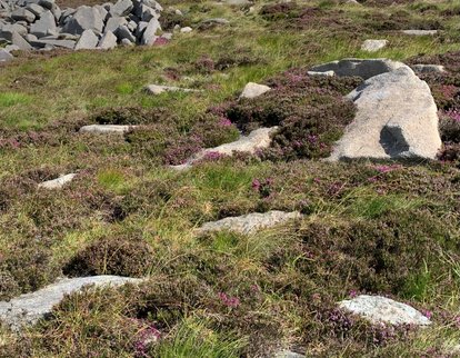
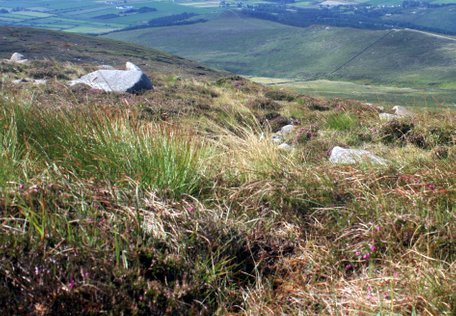
All that remains today
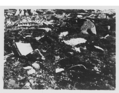
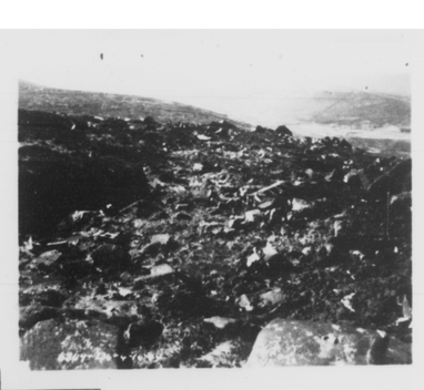
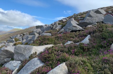
Then and now
Below are pictures taken in April 1944 and pictures taken in July 2023 at the same locations